Mount Bovis
Country:
Range: Paparoa Range
Elevation: 1252 masl 1K
Summit (Latitude, Longitude): -42.115673, 171.489208
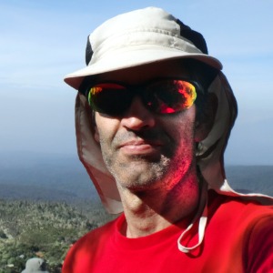 Enrique Cartagena
has summited Mount Bovis 1 time
Enrique Cartagena
has summited Mount Bovis 1 time
Mount Bovis
|
|
|
|
|
|
|
|
|
| Total | |||
|---|---|---|---|
| 10.23 km | 10.05 km | 20.28 km | |
| 5h 5min 53s | 3h 57min 32s | 9h 3min 25s | |
| 2.01 km/h | 2.54 km/h | 2.24 km/h |


The Mt Bovis Route is an official track from the Department Of Conservation (DOC) in New Zealand.
Note that DOC rates this track as Expert: Route and describes it as "Suitable for fit, experienced and well-equipped people."
To get to the beginning of the track you need to follow Bullock Creek Road, which starts right off Highway 6, two kilometres north of the DOC Visitor Centre in Punakaiki.
At the start of this 6 kilometres long gravel road you will find two warning signs. The first one states "This road is subject to SEVERE FLOODINGS during and after periods of heavy rainfall. Use at your own risk". The other one states "Not suitable for caravans, campervans and towing vehicles".
About 600 metres before getting to the end of Bullock Creeck Road we find a couple of DOC signposts. The first one warns "Bridge closed ahead. No unauthorised vehicle access" and the second one "This area is prone to flash flooding. Leave the area promptly during rainfall events". A few metres ahead we find indeed a bridge with a closed and locked barrier.
If you have a 4WD car you could cross the river, I saw some tyre marks on the river bed, but I decided to leave the car just before the two signposts where there is an ample area to park the car. There is also another DOC signpost describing the area so it looks like the recommended spot for parking the car.
Before describing the track, it is worth mentioning another excerpt from the DOC website describing it because I find it quite appropriate: "Markings exist along the route, but it's easy to come off track, especially with numerous goat tracks following and crossing the route. Rescues of lost and bluffed people have happened on this track in the past. A high level of fitness, good equipment and navigation skills are essential."
The track is quite long, over 20 kilometres return, and it took me, being a fast walker, 9 hours. DOC says between 8 to 10 hours but keep in mind that we are starting 600 meters before so it's 1.2 extra kilometres.
The track can be divided into three parts:
- From the car to the beginning of the forest:
This part is nearly 5 Km making up almost half of the route. It is completely flat and very easy walking. There is only one thing to mention and that is that a bit passed halfway (3.4 km from the start) we have to cross Bullock Creek. It is highly probable that you will get your feet wet when crossing this river. I decided to take off my shoes to make sure my feet stayed dry for the long day ahead. DOC warns "Bullock Creek can rise rapidly in wet conditions". - The forest:
This part of dense forest is about 4 kilometres, and finding your way is not always easy. Sometimes you have to go back and forth until you find the next orange marker. It is also very steep although several times you will go down and then start going up again a few meters later. Don't despair and keep fighting until you reach the clear. - The upper part:
This last part is about 1.5 kilometres. We thought the worst was over but we soon discovered that was not the case. There is so much vegetation that makes it hard to follow the track. You go up and down a few times until you find yourself walking a steep section that seems to end at the summit. Once you get to the top of that high point you realize the real summit of Mount Bovis is still quite far and to reach it first you have to go down, across, and only then start ascending the real summit.
Going down is difficult and very steep.
Going across is even harder because of how much vegetation there is. I could not find any DOC markers on this section. When going over this section I seriously thought of turning back. The advance was painfully slow and I was getting so many scratches on my arms and legs. I decided I will continue only to the end of this across section and then reassess.
Once I managed to get over the across section I looked up at the last ascent and it looked far too steep and dangerous. Since I was so close to the summit I decided I will start walking slowly and if at any point I find it too difficult I will stop and turn around.
I started walking up the last ascent and slowly kept going until I managed to get to the top. Finally, after 5 hours of hard work, I was at the summit of Mount Bovis.
After enjoying the beautiful views from the summit I started the descent.
To return to the car you follow the same exact route that took you to the summit. This means that you have to go down the steep last ascent, go over again the across section and up again to the fake summit. Due to this, going back took me 4 hours, almost as much as going up.
In summary, very long, hard, difficult but also beautiful track. I don't think I will ever come back to walk this track again due to how hard the last part was.
